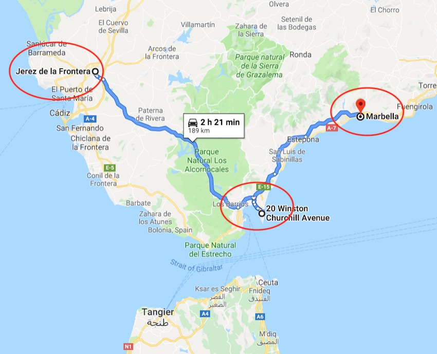
Gibraltar – More than the Rock


Map of trip from Jarez to Gibralter to Marbella
Via Google Maps

The day was still young when we once again boarded our bus leaving Jerez and heading toward our overnight destination; the Mediterranean seaside town of Marbella, Spain. This was a very busy travel day which began early.

Before we would arrive at our accommodations for the next two nights, we were going to take a quick tour of picturesque Gibraltar.


HOW THE BRITISH GAINED CONTROL OF GIBRALTAR

Gibraltar was captured by the British Fleet in 1704 during the war of the Spanish Succession. On 4th August 1704, an Anglo-Dutch fleet under the command of Admiral George Rooke took Gibraltar from the Spanish. From dawn on that day and for the next five hours, some 15,000 canons were fired from the fleet into the city. The invaders, led by the English majority, landed the same morning and not surprisingly encountered little opposition.

Under the Treaty of Utrecht in 1713 Gibraltar was ceded to Britain. This treaty stated “the town, castle and fortifications were to be held and enjoyed for ever without any exception or impediment whatsoever.” This treaty was renewed again in 1763 by the Treaty of Paris, and in 1783 by the Treaty of Versailles.

Via Historic UK – learn more at the link!

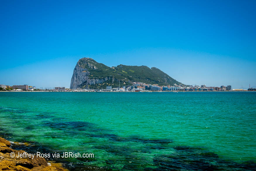
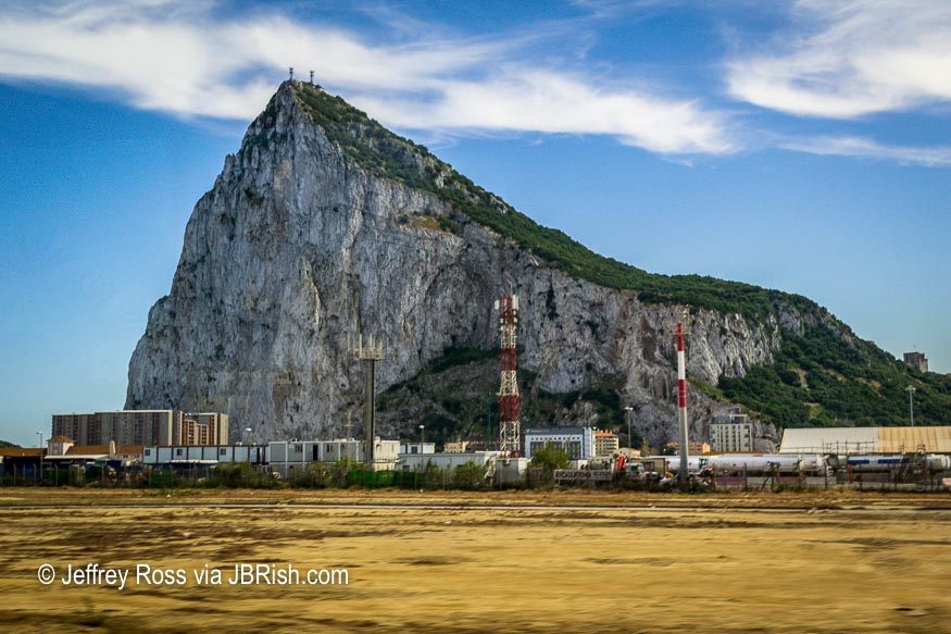
As we approached Gibraltar, the famous “rock” came into view and the waters of the strait of Gibraltar provided a fitting backdrop.


Strait of Gibraltar

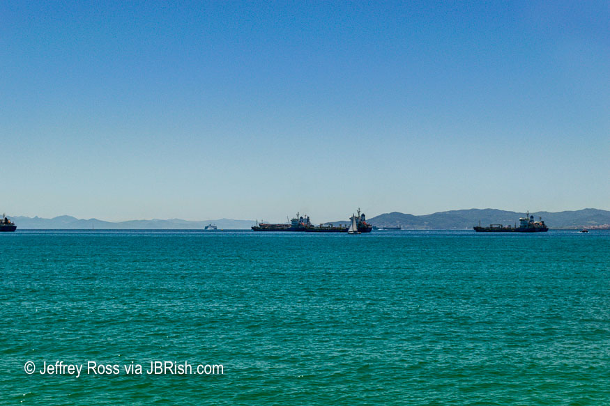
The shipping lane was busy with ships laden with their various cargoes. From the same vantage point along the road, we were able to view the Rock of Gibraltar in all of its glory.


Rock of Gibraltar - First View

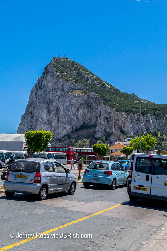
Once our traveling companions had snapped their share of the landmark. photos, we quickly made our way back to the bus and headed for the entry checkpoint with passports in hand.


Crossing the Border from Spain to Gibraltar

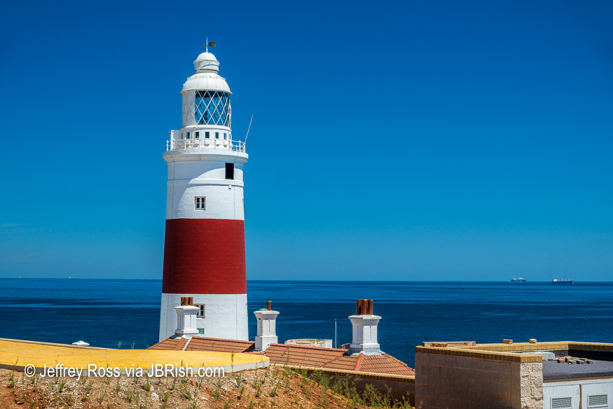
I must confess that I knew nearly nothing of what tourists might want to see prior to our tour of Gibraltar and I was pleasantly surprised. Once across the border and after we connected with a local bus driver/guide, we pulled into a waterfront rest stop known as Europa Point.

Forget the sodas, snacks and ice cream! This is a beautiful, photogenic landscape at the very tip of Gibraltar overlooking the strait. On a clear day, visitors can see Africa as we did. Apparently this is the most narrow stretch of water separating the two continents.

The colorful lighthouse against the green-blue waters caught my immediate attention; stunning!


Lighthouse at Europa Point

Also picture worthy was the ongoing construction of the Ibrahim-al-Ibrahim Mosque. Not only is it the the southernmost mosque in Europe, it is reportedly one of the largest Mosques in a non-Muslim country. King Fahd Al-Sau gifted this holy shrine to the people of Gibraltar and the world in tribute to the Moorish influence in the area.


Ibrahim-al-Ibrahim Mosque

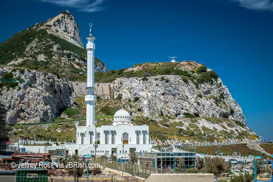
Since our visit a year ago, the mosque has been completed. You can read more about it and see current photographs HERE.

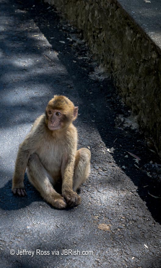
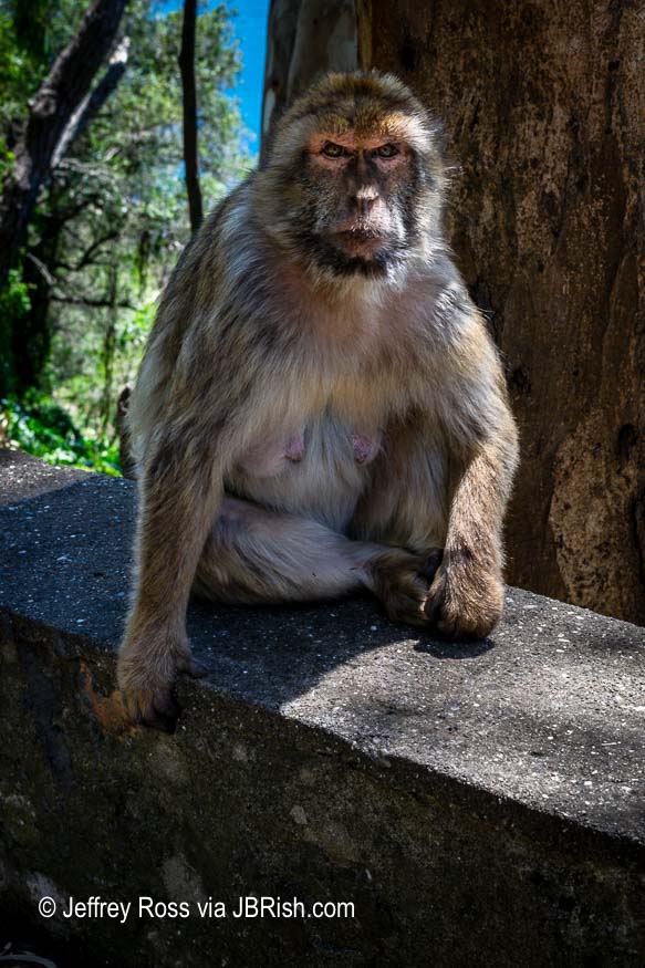
After our rest stop, it was back on the bus with our very clever, funny and informative driver/guide. Our target was the Cave of St. Michael and the famous Barbary Macaques (think monkeys) that are protected and roam the area.

Here is a brief history of the Macaques in Girbaltar:

“The macaques’ presence on the Rock gained popularity during the Great Siege of Gibraltar between 1779-1783, during which Spain and France launched an ongoing assault upon British Gibraltar by sea and land. One surprise attack – so the legend goes – was thwarted by the monkeys who were disturbed in the night, and in turn alerted the night watch to the attack. This legend gave rise to the saying that as long as the monkeys remain on the Rock, so will the British. It is also known that General George Eliott, a governor of Gibraltar in the late 1800s, would not suffer apes to be molested or taken.”

via The New Statesman – learn more at the link.


Barbary Macaque

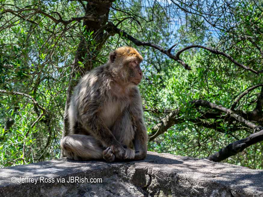
We were rightly warned to keep our belongings close as these clever denizens are quick to “steal” sunglasses, candy, ice cream or anything else they can get their hands on. One driver was very familiar to these macaques as they climbed on his window ledge to greet him as he passed by.

Visitors will want to take many pictures of the tribe as they are very cute and nonplussed by all the visitors. After all, they are the land barons at this location.

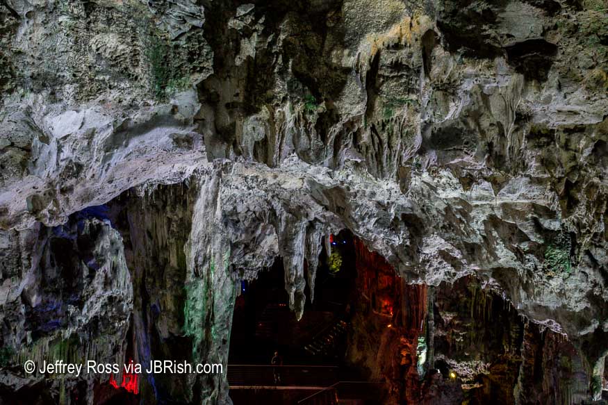
After taking several pictures, we ascended the walkway to the cave entrance. This is a beautiful cave HOWEVER, the natural structure and beauty of the attraction was, in my estimation, diminished by the use of strobe-like lights that continually changed color and cast hues across the cave formations. In addition there was music blaring in the background.


Cave of St. Michael

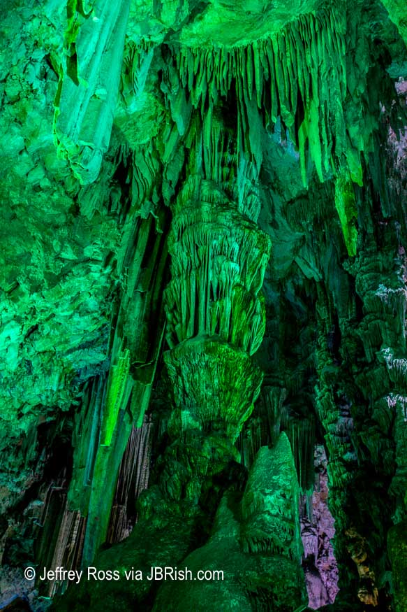
There really was no need for this as the natural beauty of this cave would certainly “speak for itself.” It was something to behold, but denigrated to a gaudy status. Sorry, but that is how I feel.

I was able to capture slightly more natural pictures during the lighting changes. You can see the color change shifting at the bottom of the frame.


Cave of St. Michael

After exiting the cave via a series of well constructed pathways, there was a bit more time for additional monkey business.


Barbary Macaque

This was a fun stop and I recommend it if you have a chance. The history is unique and interesting and the natural attractions are certainly worthy.


Barbary Macaque

Perhaps one of the best angles of the Rock of Gibraltar was from our bus window as we passed along the roadway traveling toward Marbella and a well-deserved rest!


Rock of Gibraltar - Best View


**********


***************
Continue reading about our trip to Portugal and Spain.


Read more Hiking and Exploration posts HERE


**********


All original content on this blog is copyrighted by Jeffrey B. Ross with ALL Rights Reserved. While reference links back to JBRish.com are appreciated and encouraged, please acquire approval for any reproduction of original content from this website.

©Jeffrey B. Ross 2014 – 2019 – JBRish.com


Adventures in Oregon: Hiking at Indian Beach

After our exploration of Warrenton and Seaside our next stop was Ecola State Park located between Seaside and Cannon Beach, OR.


Map showing Ecola State Park

As you will note from the following series of photographs our day at Ecola State Park’s Indian Beach started off with clouds and rain.


Surfers along the stormy beach
Surfers welcomed the waves created by the storm

The rain didn’t bother the surfers who were sure to get wet anyway, but hiking in the rain can create some challenges. We were not to be deterred however.

Other adventurers also wanted to experience the more dour mood the ocean would offer this morning.


We were not the only people intrigued by the rumbling waves
A number of beach lovers were attracted to the stormy shore

And there was enough wind and surf to accomodate those seeking the more somber beach experience.


Dark, craggy rock formations just offshore
The grey day gave a more severe appearance to the rock formations

We decided to investigate the beach area while the rain was only a drizzle as we did not know what the rest of the day would portend. We came across this sign which is not one seen on most of our hikes.


Unusual shark sighting sign
A sign not seen on a normal hiking day

In spite of the weather or perhaps because of it, the beach scene was starkly beautiful.


Stark beauty of the shore and cliffs
The cliffs and shore radiated their stark, stormy beauty

Most of the gulls tolerated the humans and did not scurry until a relatively close approach.


Seagulls gathered along the beach
Seagulls seemed to be enjoying the misty morning on the beach

The sand was covered in a palette of light browns which played well against the darker brown and black rocks.


Sand and rock created a brown palette
The storm induced palette of browns and blacks was attractive

Here the barnacles added texture to the rugged rocks.


Barnacles added texture to the rocky outcroppings

I can’t say whether or not these anemones would be as pretty on a brighter, drier day, but they were jewel-like in their emerald green tones.


Green anemone among the rocks
Emerald colored anemone among the rocks

After wandering along the beach, we decided to take a seaside hike. The description of the Clatsop Loop sounded appealing with a promise of a potential sighting of the Tillamook Rock Light (lighthouse). While we like hiking in general, the trips we enjoy most are those which have us close to the sights and sounds of nature. We did not realize the the Clatsop Loop trail would take visitors along an access road uphill. The footing was good, but we prefer wooded, non-paved terrain.

The one snap I did take along our hike uphill, was of this radiant fern among the other green vegetation and forest floor mulch.


A radiant fern along the Clatsop trail
A radiant fern seen along the Clatsop Loop Trail

The return part of the loop was much more picturesque as parts were near the shoreline or through the woods. We arrived back at the trailhead and were once again drawn to experience the changeable atmosphere of the ocean on this morning.

PS – The fog and cloudy day precluded any view of the lighthouse from the trail.


A large rock formation lined the ocean's shoreline
An abundance of large rocks along the shoreline


The seagulls continued to take advantage of the wet weather
Gulls continued to enjoy the stormy morning


Read more about Ecola State Park HERE

Read more about the Clatsop Loop Trail HERE


**********

Read previous posts about our adventures hiking and exploring in Oregon:

Exploring Astoria, Oregon – Part 1

Exploring Astoria, Oregon – Part 2

Exploring Astoria, Oregon – Part 3

Adventures in Oregon: Warrenton to Seaside


Read more Hiking and Exploration posts HERE


**********


All original content on this blog is copyrighted by Jeffrey B. Ross with ALL Rights Reserved. While reference links back to JBRish.com are appreciated and encouraged, please acquire approval for any reproduction of original content from this website.

©Jeffrey B. Ross – 2017 – JBRish.com


Adventures in Oregon: Warrenton to Seaside


After a couple of days of adventures in and around Astoria, OR, we were heading south toward Seaside. We had our itinerary planned and were excited to begin the day’s exploits.


Map route from Astoria, OR to Seaside

Living in the desert of Arizona we don’t often have a chance to visit shore towns and see nautical sights and the idea tha we could get a close up view of an actual shipwreck could not be resisted. The British vessel, the Peter Iredale, ran aground on October 25, 1906 on its way to the Columbia River and was abandoned near Fort Stevens in Warrenton. As you can see in the photo below, people can walk right up to the remainder of the wreck when the tide is low.


People can get very close to the remnants of the Peter Iredale

The hulk was quite impressive when considering it has been windswept and bathed in salt water for more than a century.


Remnants of the ship wreck draw visitors to the beach
The ship’s carcass remains after more than 100 years

Although this day didn’t provide the best weather, when the sun poked through visitors could appreciate the form and structure of the ship along with a stark beauty created by the rust tones against the blue-grey seascape.


Beauty amid the wreckage

At times, the crowds would grow as photographers and dog walkers visited the water’s edge to take in the sight. We soon moved to other areas of Fort Stevens State Park to continue our explorations.


A viewing platfrom along a jetty or breakwall at Fort Stevens Park

I never appreciated how much the west coast had prepared for invasion during WW II. Certainly Fort Stevens provided plenty of proof. This (below) was one of turrets that can be easily seen among the many other fortified batteries.


Defensive gun turret along America's western coast
Defensive gun turret along America’s western coast

After hiking one of the major trails through Fort Stevens and gaining an understanding of the military preparations there, we made our way to another planned stop, the Necanicum Estuary near Seaside. I was hopeful that we could spot a bird or two that I would be able to mark off my birding list and indeed we did pass some birdwatchers eyeing a Cedar Waxwing. Much to our surprise, it wasn’t birds that caught our attention…


Roosevelt Elk along coastal Oregon

… there was a herd of elk. They were quite numerous. One doe found us interesting, but not enough to stop eating.


An elk doe eats as she watches us walk along the path

We found ourselves in an unusual and unexpected situation as the hiking path we used to get to the bay was soon surrounded by the herd. A few males, which can weigh nearly a half a ton, were not happy that we were among their harem. We carefully made our way to the shoreline. There were some does there as well, but only a few.


Elk along the shore
Elk along the shore

Another doe nearby looked on as we approached the beach.


Another doe watched as we walked to the beach

We were able to circle around to find a clear way back to the parking area and were glad to arrive safely at the car to head to our evening’s accommodations.


More information about the Peter Iredale shipwereck

Learn more about the elk at Gerhart’s preserve

Read more about the Necanicum Estuary in Seaside


**********

Read previous posts about our adventures hiking and exploring in Oregon:

Exploring Astoria, Oregon – Part 1

Exploring Astoria, Oregon – Part 2

Exploring Astoria, Oregon – Part 3


Read more Hiking and Exploration posts HERE


**********


All original content on this blog is copyrighted by Jeffrey B. Ross with ALL Rights Reserved. While reference links back to JBRish.com are appreciated and encouraged, please acquire approval for any reproduction of original content from this website.

©Jeffrey B. Ross – 2017 – JBRish.com