Year of Yosemite (YOY) – Day 52 (Taft Point Trail Ski Markers)

NOTE: Two pictures are posted today because they are related to the “story” below. These will only count as one of the YOY picture posts, i.e. Day 52. There will be no YOY post tomorrow, but will resume on 8/15/16 (+/-).
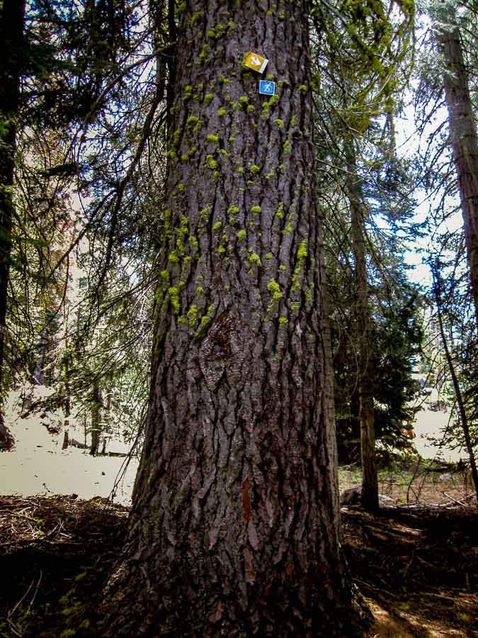
Ski trail marker mounted high on a tree 

Two trail markers mounted high on a tree along the Taft Point Trail

While hiking along the Taft Point Trail, it was unusual (at least for me) to look up and see what was mounted on the tree above. Did you notice them? I must confess that I am just speaking from conjecture here, but I interpret these as being ski trail markers. The blue sign (see below) definitely has a skier on it.

I am also going out on a limb (pun alert) by suggesting that the yellow marker (see below) is also a trail marker of sorts and is intended to stick out from the tree as it appears that there is a mounting flap that is broken which would be able to hold the sign horizontally so it can be seen from a distance.

If any readers know for sure, please confirm via a comment below. If my assumptions are incorrect, please help me clarify for JBRish readers.
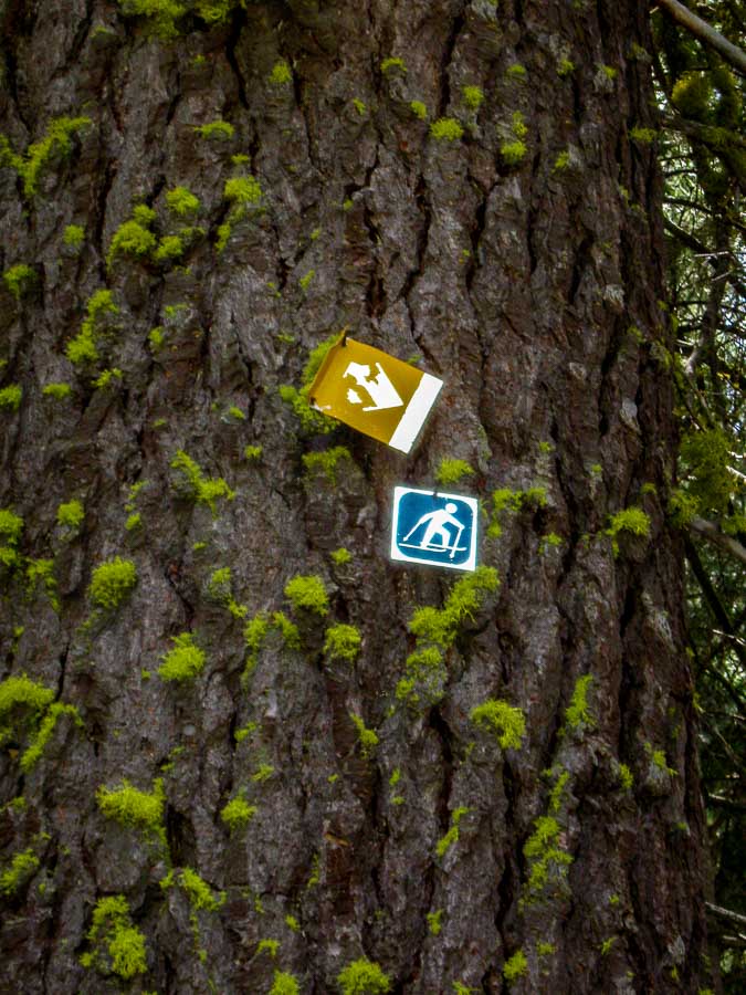
Close up of ski trail marker mounted high on a tree 

Two trail markers mounted high on a tree along the Taft Point Trail


The snow must get awfully high to have these trail markers elevated so or perhaps they do this to prevent vandalism, etc.!

 
Do you have a question about our visit to Yosemite? Ask it in the comment section.


JBRish.com originally published this post
*All photographs Copyright by Jeffrey B. Ross with all rights reserved.

 
See previous Year of Yosemite (YOY) posts HERE. If you want to read the introduction to the YOY series, CLICK HERE.

***********************************

Meta Data – No Metadata today as these are just simple jpeg snapshots to report
Year of Yosemite (YOY) – Day 51 (Lembert Dome)

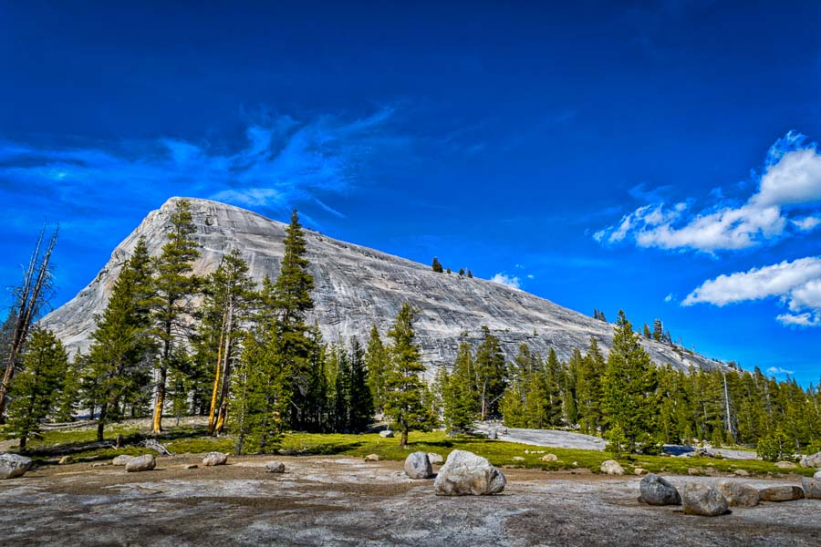
Lembert Dome from parking area 

Lembert Dome as viewed from one of the parking areas

I have posted pictures from Lembert Dome prior to this, but I thought it would be a good idea to show the entire dome. I will post more pictures of the trail and some scenery as we ascended to the very top in the future. This image was captured near one of the parking areas.

NOTE: Lembert Dome elevation is 9,449′

 
Do you have a question about our visit to Yosemite? Ask it in the comment section.


JBRish.com originally published this post
*All photographs Copyright by Jeffrey B. Ross with all rights reserved.

 
See previous Year of Yosemite (YOY) posts HERE. If you want to read the introduction to the YOY series, CLICK HERE.

***********************************

Meta Data – Day 51 YOY – Year of Yosemite

File Name: 0250.NEF
Capture time: 4:54:14 PM
Capture date: June 7, 2016
Exposure: 1/80 sec @ f/16
Focal Length: 18mm
ISO 100
Nikon D3300

Year of Yosemite (YOY) – Day 50 (El Cap and Half Dome from Tunnel View)

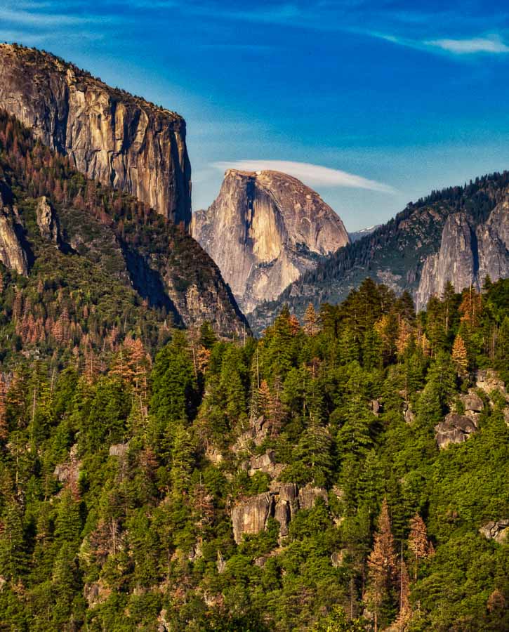
El Capitan and Half Dome as seen from Tunnel View 

A Warm glow was settling over El Capitan and Half Dome as seen from Tunnel View.

We had stopped at Tunnel View prior to this, but the light was more inviting as we cam upon this scene at this time of day and we were compelled to stop once again. El Capitan can be seen in the upper left with Half Dome close to dead-center. It is awesome to see both major icons of Yosemite in this orientation.

 
Do you have a question about our visit to Yosemite? Ask it in the comment section.


JBRish.com originally published this post
*All photographs Copyright by Jeffrey B. Ross with all rights reserved.

 
See previous Year of Yosemite (YOY) posts HERE. If you want to read the introduction to the YOY series, CLICK HERE.

***********************************

Meta Data – Day 50 YOY – Year of Yosemite

File Name: IMG_0325.CR2
Capture time: 6:07:56 PM
Capture date: June 7, 2016
Exposure: 1/200 sec @ f/8
Focal Length: 31.27mm
ISO 100
Canon SX50 HS

Year of Yosemite (YOY) – Day 49 (Morning at Yosemite Falls)

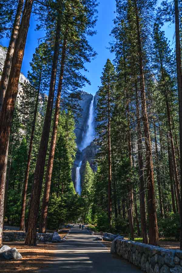
Morning at Yosemite Falls 

We started this day by walking to Lower Yosemite Falls

How wonderful is this? We started our day by walking to Lower Yosemite Falls to view this spectacular show of force and beauty. At our room nearby, we were able to hear the falls all day long. At night it lulled us to sleep!

“Yosemite Falls (2,425 ft)
Flows: approximately November through July, with peak flow in May.

Look for the ice cone at the base of the upper fall during winter and for roaring runoff April through June. Yosemite Falls, one of the world’s tallest, is actually made up of three separate falls: Upper Yosemite Fall (1,430 feet), the middle cascades (675 feet), and Lower Yosemite Fall (320 feet).

You can see Yosemite Falls from numerous places around Yosemite Valley, especially around Yosemite Village and Yosemite Valley Lodge (formerly Yosemite Lodge). A one-mile loop trail leads to the base of Lower Yosemite Fall (the eastern side of the loop, from the shuttle stop to the base of the waterfall, is wheelchair accessible).

It’s also possible to hike to the top of Yosemite Falls as a strenuous, all-day hike.” – (source)

NOTE – I looked at the webcam this morning (8/9/16) and I could not see any water flowing!

 
Do you have a question about our visit to Yosemite? Ask it in the comment section.


JBRish.com originally published this post
*All photographs Copyright by Jeffrey B. Ross with all rights reserved.

 
See previous Year of Yosemite (YOY) posts HERE. If you want to read the introduction to the YOY series, CLICK HERE.

***********************************

Meta Data – Day 49 YOY – Year of Yosemite

File Name: 0126.NEF
Capture time: 7:44:44 AM
Capture date: June 5, 2016
Exposure: 1/15 sec @ f/16
Focal Length: 18mm
ISO 180
Nikon D3300

Year of Yosemite (YOY) – Day 48 (Taft Point Fissures)

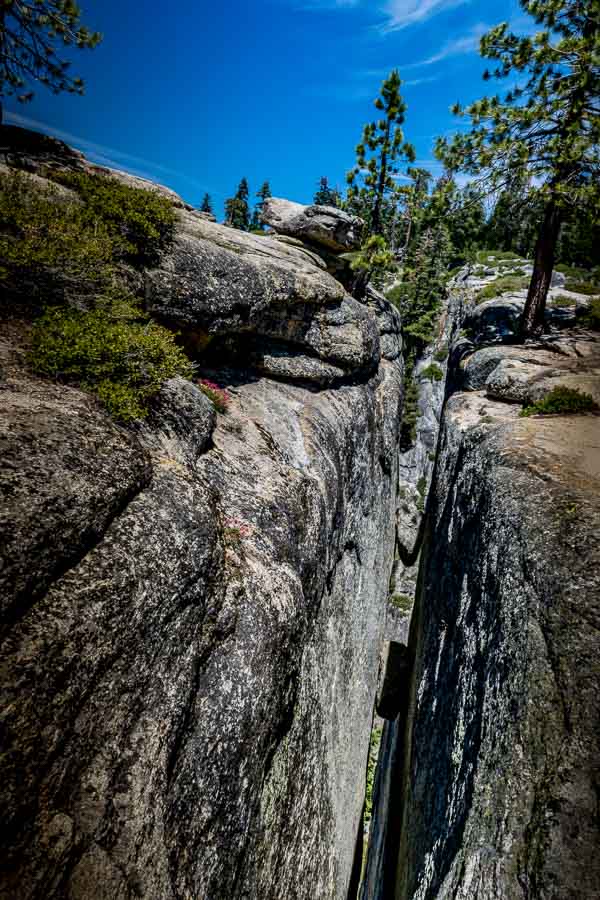
Taft Point Fissures 

The Fissures along the Taft Point Trail

I must confess that it is difficult to portray this physical phenomenon in a two dimensional picture, put fissures are large crevices (or cracks) in rocks. They can be very dangerous as they often intersect areas close to trails and form a hazard for hikers.

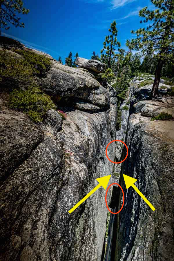
Naturally hikers need to be vigilant at all times, but when hiking with children, one needs to be doubly aware. Can you see the large crevice with the two small boulders that have fallen in the crack? That could be a person wedged in there. To make matters worse, some areas near the edge of the fissures have small shrubs along the perimieter which might camouflage them a bit.

Of course there are warning signs alerting hikers of the dangerous fissures and to alert families to hold children close.

NOTE – If you haven’t discerned the fissure, look at the picture below. The arrows point to the walls of the fissure and the red-orange ovals show the boulders that are wedged in the crack.

Taft Point Fissures Annotated 

 
Do you have a question about our visit to Yosemite? Ask it in the comment section.


JBRish.com originally published this post
*All photographs Copyright by Jeffrey B. Ross with all rights reserved.

 
See previous Year of Yosemite (YOY) posts HERE. If you want to read the introduction to the YOY series, CLICK HERE.

***********************************

Meta Data – Day 48 YOY – Year of Yosemite

File Name: 0372.NEF
Capture time: 1:52:28 PM
Capture date: June 9, 2016
Exposure: 1/60 sec @ f/18
Focal Length: 18mm
ISO 125
Nikon D3300

Year of Yosemite (YOY) – Day 47 (Rescue Gear)

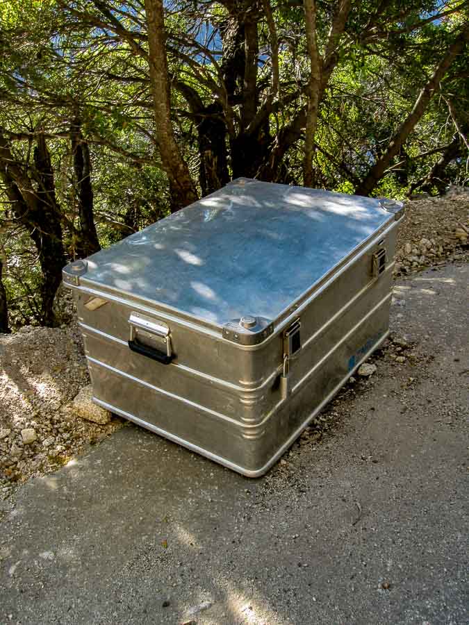
Rescue gear storage box along the Four Mile Trail 

A box of rescue gear is left on the Four Mile Trail…jut in case

While hiking the Four Mile Trail starting at Glacier Point, we noticed a metal box with a lock on it along the edge of the path. We surmise that this is a box of rescue gear that might be needed when hikers need assistance.

Notice the lock on the box which we conjecture is enough to keep the contents away from those who are unauthorized.

NOTE – If you want to see a reason why such an item might be necessary, you can review Day 25’s post Warning Signs related to the Four Mile Trail.

 
Do you have a question about our visit to Yosemite? Ask it in the comment section.


JBRish.com originally published this post
*All photographs Copyright by Jeffrey B. Ross with all rights reserved.

 
See previous Year of Yosemite (YOY) posts HERE. If you want to read the introduction to the YOY series, CLICK HERE.

***********************************

Meta Data – Day 47 YOY – Year of Yosemite (Rescue Gear)

File Name: 3520.JPG
Capture time: 6:10:41 PM
Capture date: June 6, 2016
Exposure: 1/60 sec @ f/4.0
Focal Length: 5.8mm
ISO 80
Canon PowerShot A590 IS

Year of Yosemite (YOY) – Day 46 (Tuolumne Meadows)

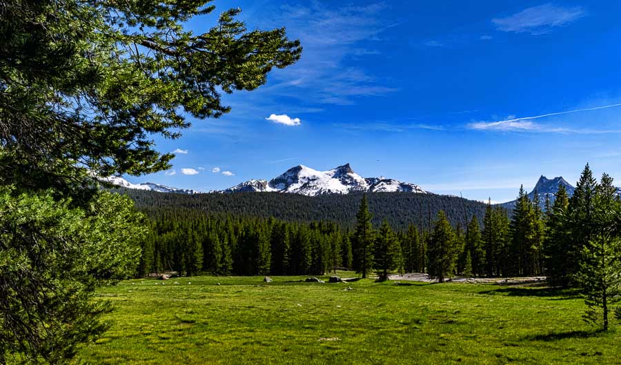
Tuolumne Meadows viewed from the Lembert Dome TrailTuolumne Meadows viewed from the Lembert Dome Trail
After a full day of hiking, we were descending from our trek to Lembert Dome and Dog Lake when we came upon this pretty view of Tuolumne Meadows. Cathedral Peak can be seen just to the right of the photo. As we were nearing the parking area, we thought we saw a beaver go scampering across a snowy patch in the distance, but as we later decided, it must have been a marmot.

 
Do you have a question about our visit to Yosemite? Ask it in the comment section.


JBRish.com originally published this post
*All photographs Copyright by Jeffrey B. Ross with all rights reserved.

 
See previous Year of Yosemite (YOY) posts HERE. If you want to read the introduction to the YOY series, CLICK HERE.

***********************************

Meta Data – Day 46 YOY – Year of Yosemite

File Name: 0248.NEF
Capture time: 4:42:24 PM
Capture date: June 7, 2016
Exposure: 1/60 sec @ f/16
Focal Length: 22mm
ISO 100
Nikon D3300

Year of Yosemite (YOY) – Day 45 (Half Dome at Sunset)

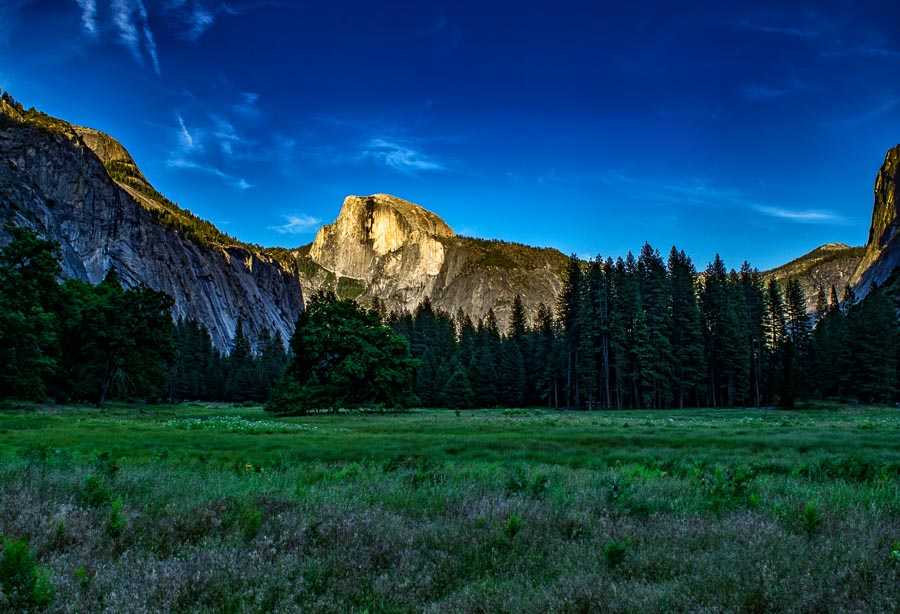
Half Dome Meadow at SunsetHalf Dome Meadow at Sunset

While Half Dome is always impressive as it rises up from a multitude of vantage points at Yosemite, during the sunrise and sunset hours it takes on a special majesty. I particularly like this photograph with the contrasting dark colors of green and some purple highlights among the wildflowers in the foreground.

This field was only a short walk from our lodging and it was difficult to get enough of this view!

Fact: Did you know that the North Face outdoor company uses a stylized version of Half Dome as their Logo?

North Face Logo 

The North Face Logo is a Copyrighted and Registered Trademark

 
Do you have a question about our visit to Yosemite? Ask it in the comment section.


JBRish.com originally published this post
*All photographs Copyright by Jeffrey B. Ross with all rights reserved.

 
See previous Year of Yosemite (YOY) posts HERE. If you want to read the introduction to the YOY series, CLICK HERE.

***********************************

Meta Data – Day 45 YOY – Year of Yosemite

File Name: 0277.NEF
Capture time: 7:06:37 PM
Capture date: June 7, 2016
Exposure: 1/20 sec @ f/14
Focal Length: 18mm
ISO 100
Nikon D3300

Year of Yosemite (YOY) – Day 44 (Rocks Along the Mirror Lake Trail)

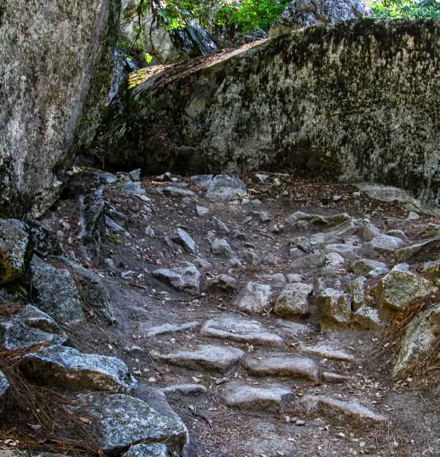
rocky part of the trail to Mirror LakeThe Yosemite Park trails are maintained, but there are rough spots
Many of the trails at Yosemite lead hikers through a variety of ecosystems, i.e. wooded, meadow, open, etc. Generally the trails are quite passable, but one needs to look where they are going as there are sections that crop up now and again with large embedded rocks that seem to grab at the toes of hiking shoes.

The picture above is one bend in the trail to Mirror Lake that is indicative of this type of terrain. Footing can be tricky so hikers are advised to step cautiously.

 
Do you have a question about our visit to Yosemite? Ask it in the comment section.


JBRish.com originally published this post
*All photographs Copyright by Jeffrey B. Ross with all rights reserved.

 
See previous Year of Yosemite (YOY) posts HERE. If you want to read the introduction to the YOY series, CLICK HERE.

***********************************

Meta Data – Day 44 YOY – Year of Yosemite

File Name: 3498.JPG
Capture time: 10:08:46 AM
Capture date: June 5, 2016
Exposure: 1/13 sec @ f/7.1
Focal Length: 5.8mm
ISO 200
Canon PowerShot A590 IS

Year of Yosemite (YOY) – Day 43 (Bridalveil Falls)

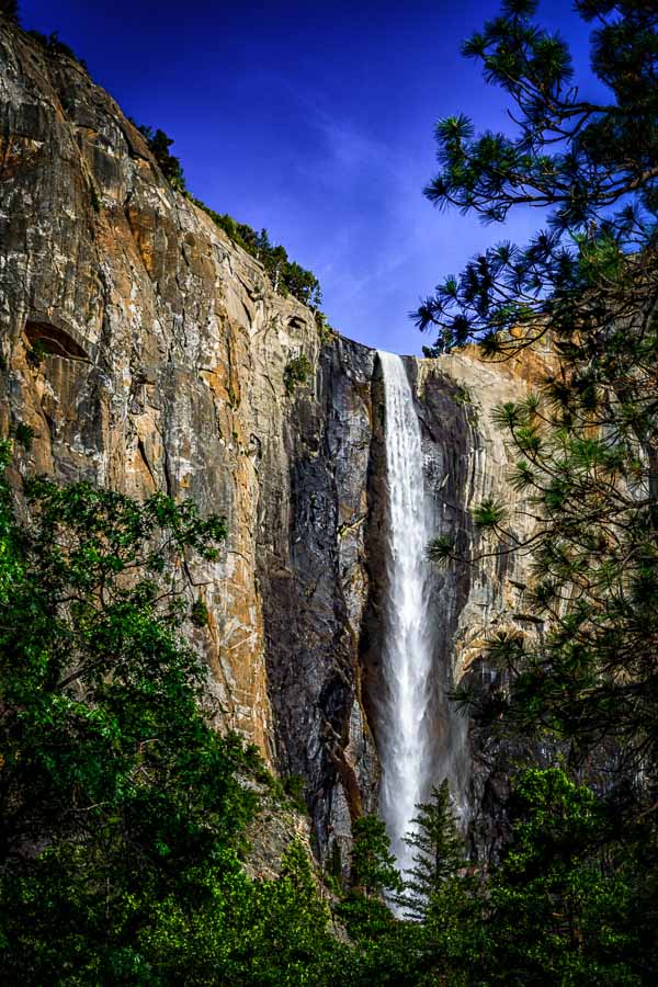
Bridalveil Falls flowing well 

Bridalveil Falls flowing well

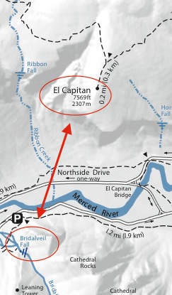
Across the “way” from El Capitan is another beautiful feature, Bridalveil Falls. If you look at the map below, you can see that they are almost directly opposite one another and while it looks like quite a distance on the map, from the road, they are relatively close. Parking can be tight at this location because visitors stop to take photographs of both iconic scenes.

Map of Bridalveil Falls and El Capitan 

On the map above, El Capitan and Bridalveil Falls are circled with an arrow pointing to each.

NOTE: Insert above is taken from the National Park Service Yosemite Valley Hiking Map

 
Do you have a question about our visit to Yosemite? Ask it in the comment section.


JBRish.com originally published this post
*All photographs Copyright by Jeffrey B. Ross with all rights reserved.

 
See previous Year of Yosemite (YOY) posts HERE. If you want to read the introduction to the YOY series, CLICK HERE.

***********************************

Meta Data – Day 43 YOY – Year of Yosemite

File Name: 0264.NEF
Capture time: 6:31:48 PM
Capture date: June 7, 2016
Exposure: 1/60 sec @ f/16
Focal Length: 50mm
ISO 100
Nikon D3300