Petroglyphs: The Writing on the Wall

Petroglyphs are images scratched into rocks using other rocks or instruments. In the desert, rocks often gather a dark patina that can be chipped away to reveal a lighter surface underneath. These are ideal surfaces for creating petroglyphs.

These drawings are found in many locations around the world. and those created by ancient peoples tend to hold a certain mystique.

NOTE: – Paintings on rocks are referred to as pictographs or petrographs.

Some Petroglyphs are relatively recent, perhaps as young as the early twentieth century while others are tens of thousands of years old.

During our many hikes across the United States, we have seen a number of established petroglyph sites.

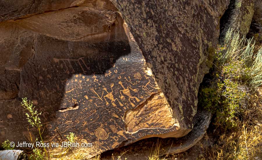
One of the most interesting encounters was Newspaper Rock State Historic Monument in Utah which can be found along the main road leading into the Needles section of Canyonlands National Park.


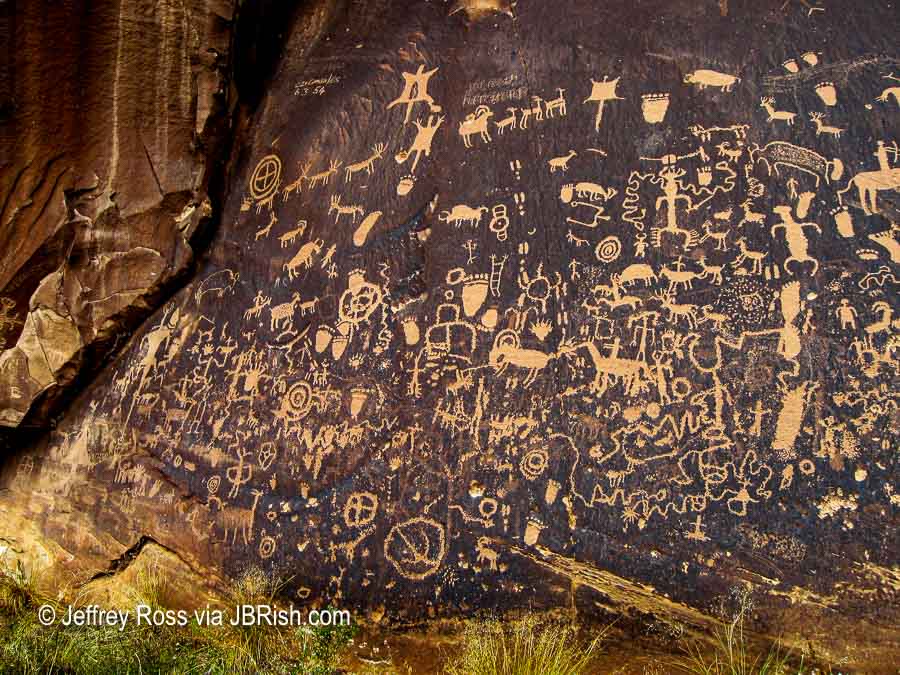
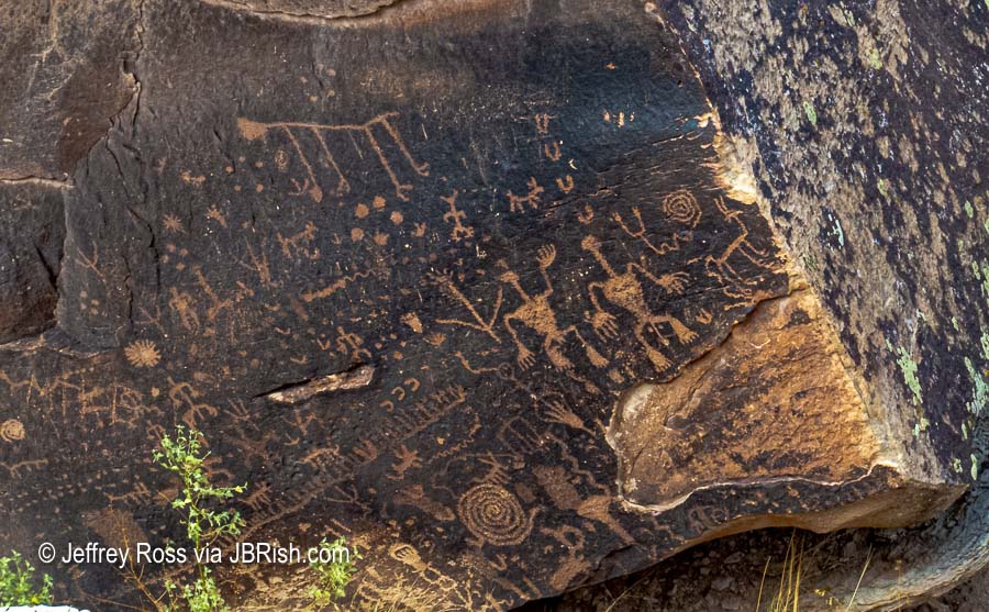
The photo above was of the left-hand side of the main display. A number of the images are self-explanatory while others remain mysterious. These are estimated to be 2,000 years old according to the park’s website.


This lighter section was a less “populated” area even farther left of the area shown above. It is amazing how well the petroglyphs have stood the rigors of weather over time. Notice that some drawings such as the feet and the quartered circle are repeated in a number of areas shown in the photographs.


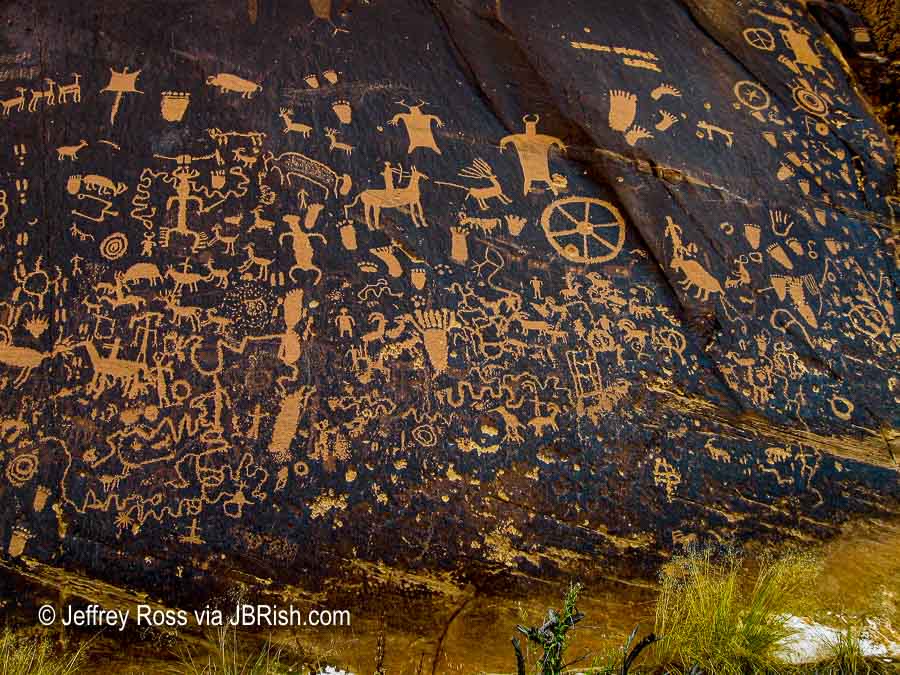
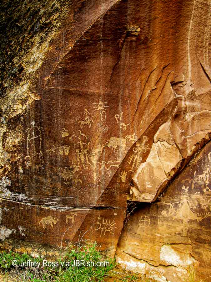
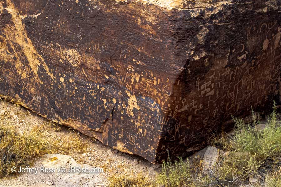
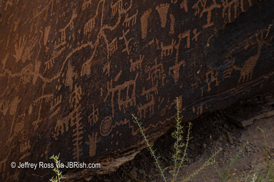
The last section, located on the right-hand side of the monument, is carved on very dark rock. A variety of animals and hunters can clearly be seen.

What I find almost equally astounding is that these images do not seem to have been defaced. There is only a short fence blocking off this ancient canvas which could easily be breeched. Kudos to the thousands of visitors who have admired this precious view into the past and have kept it safe for others to witness.

Read more abut Newspaper Rock HERE


Valley of Fire State Park, Nevada

We were fortunate enough to have time to visit petroglyphs at the Valley of Fire State Park. Although these were not at ground level, a scaffolding was erected to enable easy viewing of the ancient artistry.


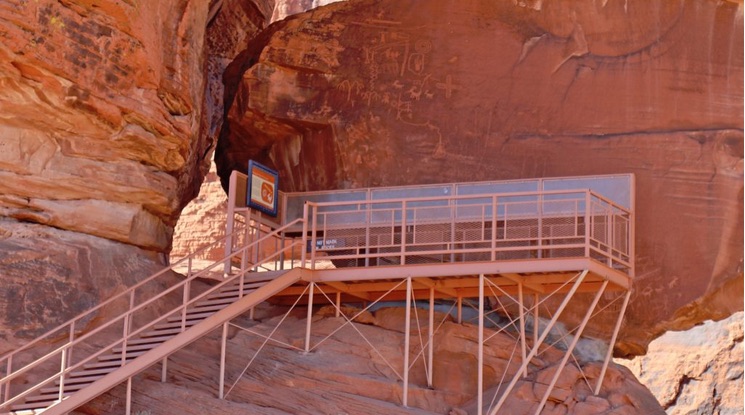
Picture courtesy of Park Ranger John website

Valley of Fire State Park

A number of the images were similar to those at other sites.


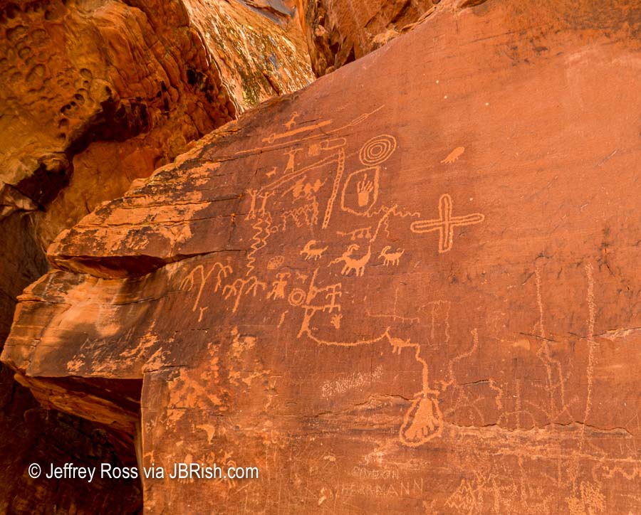
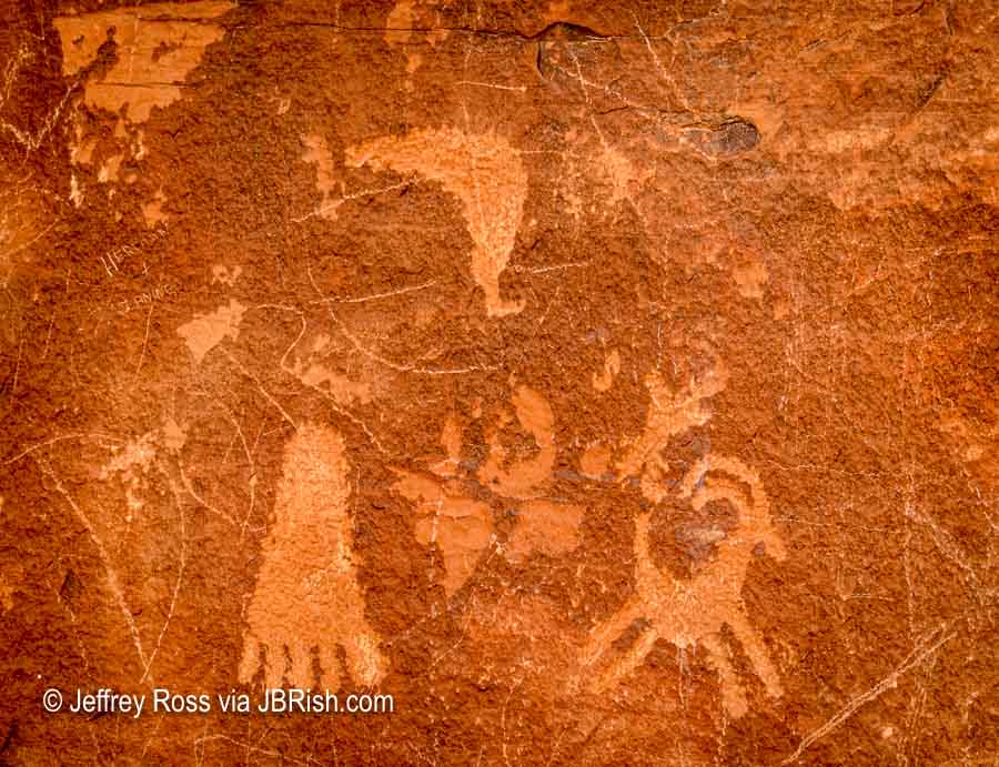
Unfortunately there was some alteration, or more accurately, violation of these ancient treasures, shown in the picture below via the circle.


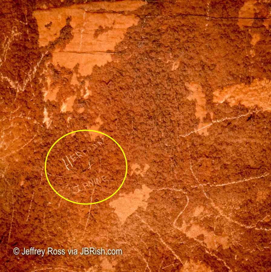
The names Herman and Janine were carved into the face of the large rock.


Painted Desert – Another Rock, Another Newspaper

The Painted Desert also has a Newspaper Rock although it is not as easy to “read” as the Canyonland’s Edition.

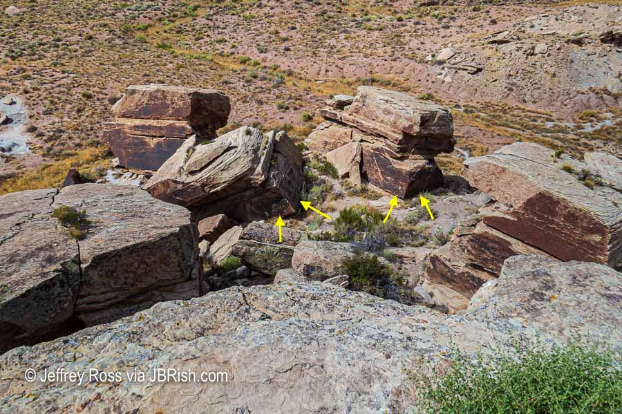
The artifacts can be viewed from a fenced-off, elevated area just a short walk from the large parking lot. Don’t expect to get a good picture of the actual drawings unless you have a camera with a fairly large telephoto lens.

This is what you will see from the viewpoint above the rock formation. I have placed yellow arrows where the petroglyphs are located. On a sunny day, there is shade covering much of the surface (obviously depending on the the time of the day) making them difficult to see with the naked eye.


There are free viewing machines (mechanical binoculars) that assist visitors in visualizing some of the drawings. These are not always optimal as dust and dirt on the lenses and loss of definition related to location in such a harsh environment degrades the lenses.

NOTES:

I am not suggesting that people be allowed to approach these ancient treasures and, as demonstrated above, perhaps it is a good thing for their own protection.

The pictures below were not captured with a standard 35mm camera and thus the ranges given are approximately estimated for a full-frame digital camera.

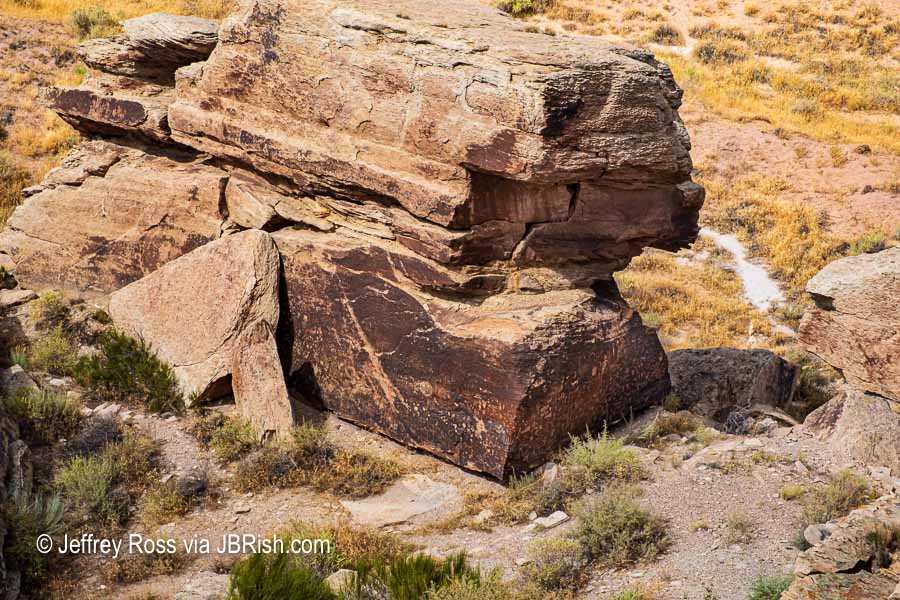
With a telephoto lens ( 80mm +/-), we can get closer…


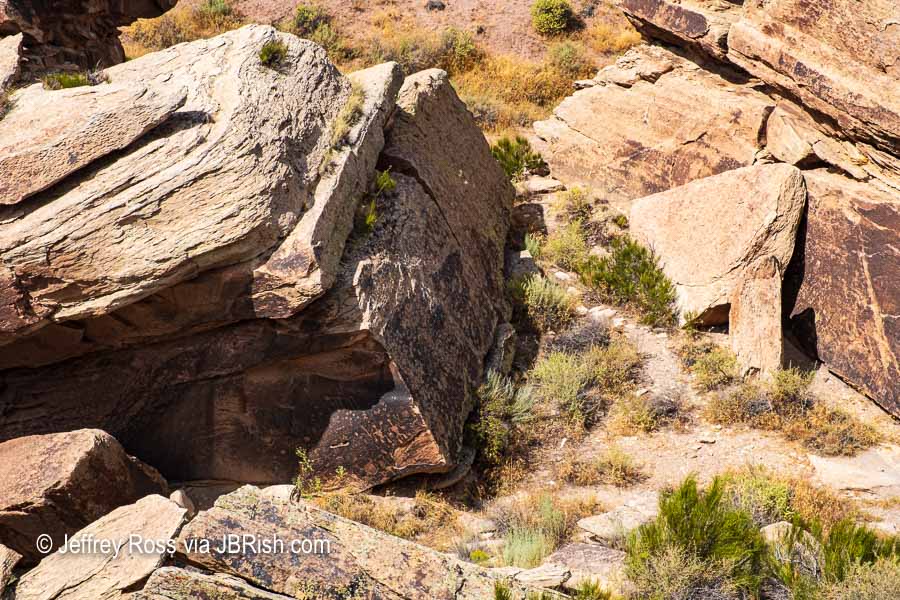
At approximately 300 mm (+/-) the drawings become quite clear:


Moving in a bit closer, we can see even more detail.


At the maximum length of the crop sensor lens on my canon HS50xs Powershot, we get a closer look, but some detail is blurred.


Once again, we see similarity to petroglyphs from other sites.


Tours by the Old Pueblo Archaeology Center are available for some of the petroglyph sites at the Petrified Forest.

Read more about Petroglyphs and Petroglyph National Monument in New Mexico

If you enjoyed this post, you can read more miscellaneous stories on JBRish HERE


**********

All original content on this blog is copyrighted by Jeffrey B. Ross with ALL Rights Reserved. While reference links back to JBRish.com are appreciated and encouraged, please acquire approval for any reproduction of original content from this website.

©Jeffrey B. Ross 2014 – 2019 — JBRish.com


Merida, Spain – Ancient Roman Ruins

Merida, Spain is approximately two hundred miles southwest of Madrid and only a 3.5 hour ride from Lisbon. Tours of both Portugal and Spain often stop at this UNESCO World Heritage site to gaze upon the well-preserved ruins and monuments dating back to a time prior to the Christian era.

What makes Merida special among other cities on the Iberian peninsula is that it was one of the ancient Roman Empire’s most important cities and as such is home to numerous ruins. There are apparently more Roman monuments in Merida than any other Spanish municipality.

Just a short walk from the visitors center, the ruins become visible.

Distant view of the Ancient Roman Ruins of Merida, Spain

As we walked closer to the ancient structures, there were signs of the modern city which envelops this unique part of history (notice the rooftops and tower rising above the rim of the ancient walls in the background).


A closer view of the Ancient Roman Ruins of Merida, Spain

On the way to a central area, our guide pointed to a series of horizontal rocks (below) strategically placed in the middle of the “road.” Notice that there are three large structures that elevate well-above the surface. These served the purpose of our modern day speed bumps. Ancient vehicles would have to navigate these hindrances by slowing down to keep the wheels on each side of the middle obstacle.


Ancient Roman Speed Bumps

One of the two main attractions is the amphitheater. Visitor access is through the entry arch.


Archway leading to the amphitheater.

This is a view of one side of the circular area which is not fully restored.


Part of the  amphitheater partially restored

Perhaps this a better view from a bit farther away. The partially restored amphitheater shows the contrast between how it probably looked during the Roman Empire and how it was discovered; a then and now comparison.


A better view of the restored and unrestored amphitheater


Another view of the  amphitheater ruins

As depicted in many Hollywood films, this structure was used for gladiatorial combat. One can imagine the combatants walking through the entrance tunnels knowing what was facing them at the other end.


Gladiator tunnel leading to the activity circle of the amphitheater


Tourists walking through Gladiator tunnel leading to the activity circle of the amphitheater


 Opening of one of the tunnels leading to the activity circle of the amphitheater

With large crowds shouting for the victory of their favorite gladiator, the throngs needed a place to take care of their biological needs. A latrine area is pictured below.


latrine for attendees

As we walked through the restoration project, we noted some stones had a large “R” chiseled onto their face. The guide explained that the “R” signified that this was not an original stone, but a reproduction.


Restoration stone, not original

There were many original stones that have survived the centuries.


Many old original stones remain

Leaving the gladiator ring, we headed to the theater which is still used for summer productions.


Distant view of the theater nearby

Amid the scaffolding notice the statues between the columns. These are beautiful works of art representing this historic period.


A closer view of the theater, scaffolding and statues

Let’s take a closer look at some of these statues


Closer view of some of the statues


Closer view of some of the statues


Closer view of some of the statues

Some had names of their likeness (Tiberio Claudio Nero and Druso El Mayor)…..


Closer view of some of the statues

and Cayo Julio Cesar Agusto


Closer view of some of the statues

Walking through these old and almost unfathomable ruins, one cannot help being awestruck by the history and craftsmanship represented by these stone structures.


Beautiful ancient stonework

See a brief video of the Theater.

The areas immediately surrounding the ruins have been modernized with gardens, paths and water features. Rather than detract, they frame the Roman creations.


Light pink and purple flowers among the ruins


Gardens enhance the surrounding area

The importance of the UNESCO World Heritage site does note escape visitors as there are reminders throughout the town. This was a view from the front window of our bus. Notice the replica of a Roman column ruin at the center of the traffic circle.


Traffic circle with replica of a Roman column in the center

As with many magnificent finds such as this, there is often a yin and a yang. As the town plans for modern buildings, additional ruins are often uncovered. In many instances, construction must then stop and assessments made. This often delays, or in the worst case, cancels any renovations or building. As we can imagine, this must be very frustrating to current residents of Merida wanting to upgrade their properties.


Modern reconstruction delayed or canceled because of finding ruins

On the way out of town, we passed another impressive sight, a portion of the Acueducto de los Milagros (Miraculous Aqueduct). Only a small portion of the aqueduct bridge stands today. Many of the granite blocks were taken to be used on other structures before the aqueduct was a protected legacy.


Acueducto de los Milagros

Storks are fond of nesting atop tall structures and being an ancient, historical piece of history does not concern them. The White Stork is given protected status in Spain and many towns make sure they are cared for because they are of interest to tourists.


Storks nesting atop the Miraculous Aqueduct

Of course after such an excursion, we needed to stop for lunch. This is the Parador de Merida.


Parador de Merida - a fine lunch or dinner stop

The ride through the countryside to our next stop, Seville, was charming and picturesque.


Countryside on the way to Seville

Even the requisite rest stop provided intersting sights such as large pig legs and other meats offered for sale. One sign is for Paleta Ibérica Bellota, acorn-fed free range pigs. Interestingly enough hams from front and rear legs are differentiated: paleta is ham from the front leg while jamon would be from the rear leg. One famous producer is Fermin in Salamanca, Spain. (read more HERE)


Hams for sale at a highway rest stop

Learn more about The Roman Theatre of Mérida HERE


Next stop, Seville


**********


***************
Continue reading about our trip to Portugal and Spain.


Read more Hiking and Exploration posts HERE


**********


All original content on this blog is copyrighted by Jeffrey B. Ross with ALL Rights Reserved. While reference links back to JBRish.com are appreciated and encouraged, please acquire approval for any reproduction of original content from this website.

Portugal – Historic Evora


As noted in my previous post about Evora, the town is quaint with typical Portuguese trappings such as the red-orange tile roofs, tiled walls, etc. It is the typical mix of the very old, the old and the new.


Historic Evora with tile roofs

Most towns in Europe, and Portugal is no exception, have a major square. This is the somewhat understated square in the center of Evora.


Evora's town square

It was another beautiful day enjoyed by all. Small balconies open on to the square to allow even the smallest apartments to have a view of what is taking place below.


A dog sitting on a small balcony

This unusual storefront is an example of the old style mixed with modern accents. Notice the contemporary wooden door and the security system in the upper-left.


A shop with a mix of the old and the new

The drain pictured below was part of the ancient aquifer system…


A pipe from the ancient aquifer

and this water box was part of the Silver Water aqueduct storage facilities.


Ancient water storage facility

Narrow side streets in the old part of town where support beams cross the alleyways to help stabilize the walls of the buildings had many twists and turns.


A side alley

Once again we see tiles used as artistic accents outside this ceramic and craft shop. The name of the shop, Artesanato Beijinho, translates to Handicrafts Kiss.


A craft shop with tiles and ceramics

Little did I know prior to this trip that Portugal produces nearly half of the world’s supply of cork. Apparently those countries in and around the western Mediterranean have ideal conditions for the cork oak (Quercus suber L.) When considering countries that have the ability to grow this tree, it is said that: “…Portugal, rightly occupies the foremost position. It has 500 factories, which employ about 20,000 workers…” and “Cork is the most important of Portuguese exports and alone represents about 16 percent of the total foreign income derived from trade.**”

** The cork industry in Portugal

At one stop, our guide showed us a piece of the bark from this tree as she explained role Evora plays in this prolific Portuguese industry.


cork tree bark

Here she demonstrates the thickness of the bark and how corks are punched from their casing. We were able to find many items made from cork including hats and pocket books.


How corks are punched out of the bark

Evora is also home of fabulous ruins of The Roman Temple. Read more about the Temple by clicking HERE. Our guide had a pictorial representation of how the original temple appeared when complete.


Ancient Roman ruins


Picture of the completed ruins as they were

Évora’s cathedral (Sé Catedral de Évora) has architecture influenced by the Moors and thus resembles a fortress. The Christians who later inhabited this area, made their own modifications to the structure. This is touted as the largest medieval cathedral in the country. While it’s main facade can be seen from far away, I particularly liked this side view from a nearby courtyard.


A side view of Evora's Cathedral

The main chapel contained an ornate altar constructed and trimmed in the Baroque style and is one reason why it was declared a UNESCO World Heritage site.


Main chapel of Evora's Cathedral

Perhaps one of the most curious artistic touches is the statue of a pregnant Virgin Mary.


statue of a pregnant Virgin Mary

Before leaving, we had a pleasant and very worthy lunch at the historic Pousada Convento de Evora – Hotel Loios.


sitting room of the Pousada Convento de Evora – Hotel Loios

Even the sign for the men’s restroom had a creative, artistic touch!


Men's room sign of the Pousada Convento de Evora – Hotel Loios

Our last stop in Evora this day was at another historic hotel and spa, the Convento do Espinheiro, developed from an 1834 monastery. We occupied one of the older heritage rooms which was crafted from monk’s quarters and exuded old world charm.


 the Convento do Espinheiro

As one might anticipate, there were areas of the old monastery that were preserved as unique and beautiful examples of religious architecture. The Church of Our Lady of Espinheiro is open to guests and they are encouraged to visit and admire the various artworks.


Church of Our Lady of Espinheiro

Also worthy and unique was the Restaurante Divinus with vaulted ceilings in the dining area. It was quite romantic and offered excellent cuisine.


 Restaurante Divinus with vaulted ceilings


 Restaurante Divinus with vaulted ceilings

There is much to explore both inside and out. The sitting room below was laden with antiques and had cozy seating areas!


sitting room with antiques

There was a special resident we were pleased to find as we explored the hotel grounds.


resident cat

As devotees of gardens and plants, we were also delighted to pay homage to an olive tree that was more than one thousand years old.


Very old olive tree

Before settling in and preparing for dinner, we walked to the front of the hotel and crossed the small village road opposite to take a distant glance at Evora from afar.


Evora from afar


***************
Continue reading about our trip to Portugal and Spain.


Read more Hiking and Exploration posts HERE


**********


All original content on this blog is copyrighted by Jeffrey B. Ross with ALL Rights Reserved. While reference links back to JBRish.com are appreciated and encouraged, please acquire approval for any reproduction of original content from this website.

©Jeffrey B. Ross 2014 – 2019 – JBRish.com


Photography: My Shot — Aged Doorway – Sintra, Portugal


An Old Historic Doorway in Sintra, Portugal

If you have done much traveling of any kind, you might have seen posters, T-shirts or other artwork that depicts interesting doorways of a particular city. Perhaps they were doorways of Boston, doorways of Georgetown or doorways of San Francisco, etc.

I am a sucker for old or unique doorways. The picture above is of a doorway we came across in Sintra, Portugal in the vicinity of the National Palace of Sintra. This doorway is reminiscent of a bygone ancient era. The wood is old, cracked, discolored and partially rotted. The metalwork is well-used and rusted, but still attractive in design. The doorway exudes character!

The craftsmanship is enhanced by the cementwork frame and the ornamental details increase the beauty of the entranceway. Onlookers quickly come to understand that this building has been an eyewitness to history.


**********

Metadata

File Name: DSC_2646.NEF
Capture time: 11:18 AM
Capture date: May 10, 2018
Exposure: 1/60 sec @ f/9
Focal Length: 18mm
ISO: 180
Camera: Nikon D3300
Lens: 18.0 – 55.02mm f/3.5-5.6
Edited in Lightroom & Photoshop

**********

See more photography posts HERE and visit Jeff’s Instagram site HERE


**********


All original content on this blog is copyrighted by Jeffrey B. Ross with ALL Rights Reserved. While reference links back to JBRish.com are appreciated and encouraged, please acquire approval for any reproduction of original content from this website.

©Jeffrey B. Ross – 2018 – JBRish.com


Adventures in Oregon: Garibaldi’s Graces and Pier

Wheeler was a fun stop. We enjoy small towns with their the local, small-shop milieu which generally offers homey, welcoming touches.

Another stop we targeted was an unusual rock formation in Garibaldi, OR known as The Three Graces which are millions of years old.


The Three Graces with blue skies!

Here is a description:

The Three Graces

Nestled near the shore in the channel leading from Garibaldi to the North Jetty and the Pacific Ocean is a picturesque rock formation known as the Three Graces. The rocks are a favorite of birds and photographers and, at their base, they feature tide pools and excellent beach combing. http://visitgaribaldi.com/three-graces/

As you can see, the weather was very variable, but this helped create some dramatic views of The Graces


A wider view of the graces and vicinity

It was a short, but sometimes challenging walk down to the shore where the tide pools collect during low tide. The rocky coastline makes the footing a bit tricky and when wet, perhaps not good for those without the appropriate footwear and good balance.


The shoreline was quite rocky and footing difficult
The shoreline was quite rocky and footing difficult.

Interestingly enough there was another fascinating rock near the Three Graces that was itself quite interesting. I tried to find a name for it, but was unable to determine any label, but if you visit you are sure to see it.


Another just interesting rock formation nearby
A neighbor to the three graces was just as interesting!

I particularly enjoyed the window at the base which enabled a peek into the distance.


See the distant shore via nature's window
See the distant shore via nature’s window.

Perhaps the best place to park if visiting the formation is about a half mile or so north along the railroad tracks which were also quite scenic.


A bend in the railroad tracks
What’s behind the bend?


Stonework for the elevated roadway
Nice stonework in the roadway wall.

Once we saw the Three Graces from as many angles as the weather and footing would encourage, we headed to the village of Garibaldi. We weren’t too sure what we would discover, but it proved to be a good find.

Most of our time was spent on and around the Garibaldi pier which was charming and had a number of attendees “fishing” for Dungeness crabs.


Garibaldi's pier beckons fishermen.
Garibaldi’s pier beckons fishermen.

“At over 700 feet in length, Garibaldi’s Pier’s End pier is the longest in Oregon. It is located across U.S. Highway 101 from the historical Coast Guard Headquarters building. Near its end is a building that served as a boathouse for the Coast Guard from 1934 until the early 1960s. The Port of Garibaldi took ownership of the pier as part of a land swap with the federal government in the late 1970s. Although the building is under private lease, the pier itself is open free to the public for a wide range of recreational fishing opportunities, including crabbing, bottom fishing for sturgeon and other species, and salmon fishing. A stairway provides public access to the clam beds below. There are several turnout locations for setting up chairs while tending your crab pots or fishing lines. The pier is open from dawn to dusk. To access Pier’s End, take 12th Street from U.S. Highway 101 and turn right on Bay Lane. There is parking near the entrance to the pier.” – http://visitgaribaldi.com/piers-end/

The shoreline was dotted with some boating-related industries and every now and again, a few small fishing boats would pass by.


A boat with anglers heading home.

The cormorants seemed to be taking the day in stride as they took time to dry their feathers on adjacent pylons.


Cormorants are also hoping for some fish.

As we were leaving, I couldn’t resist just one more photograph. Here it is rendered in a near black and white version which captures the mood of that day.


Beautiful picture of the Garibaldi Pier
A favorite photograph of the Garibaldi pier taken as we were ready to leave.


**********

Read previous posts about our adventures hiking and exploring in Oregon:

Exploring Astoria, Oregon – Part 1

Exploring Astoria, Oregon – Part 2

Exploring Astoria, Oregon – Part 3

Adventures in Oregon: Warrenton to Seaside

Adventures in Oregon: Hiking at Indian Beach

Adventures in Oregon: Views from Ecola Point

Adventures in Oregon: Movin’ On Down the Road


Read more Hiking and Exploration posts HERE


**********


All original content on this blog is copyrighted by Jeffrey B. Ross with ALL Rights Reserved. While reference links back to JBRish.com are appreciated and encouraged, please acquire approval for any reproduction of original content from this website.

©Jeffrey B. Ross – 2017 – JBRish.com