Vide-Ohs: Dust in the Blood (Hiking the Grand Canyon)

JBRish readers know that one thing we enjoy and write about on this blog is hiking and exploring natural places. We appreciate all forms of wildlife and types of terrain, but the mountains and canyons have a special pull on our adventurous spirit.

The Grand Canyon is indeed one of earth’s treasures and it is a shame that mankind has tried to take advantage of its bounty by harvesting natural resources and obliterating some of the pristine beauty.

Below is just one photograph I took on our visit to the North Rim. It was taken with a very simple point-and-shoot camera with only 8 megapixels of resolution when most of today’s cameras start at twice that number and many go to three or four times that and beyond.


North rim of the Grand Canyon near the Lodge

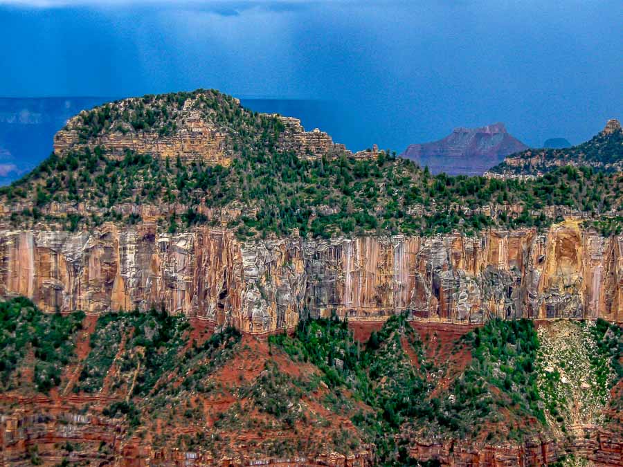
Even with the limited ability of the camera and the photographer, I think you will agree that this is a pretty, colorful picture taken near “the Lodge” at the north rim of the Grand Canyon.

I am also sharing the trailer to the movie Dust in the Blood detailing the journey of filmmaker/photographer Pete McBride and writer Kevin Fedark as they try to hike the 750 mile length of the Grand Canyon.

Dust in the Blood – Trailer from Pete McBride on Vimeo.

From the Vimeo web page hosting the trailer:

In 2016 filmmaker/photographer Pete McBride and writer Kevin Fedarko set out on a 750-mile journey on foot through the entire length of the Grand Canyon. From the outset, the challenge was far more than they bargained for. More people have stood on the moon than have completed a continuous through hike of the Canyon. McBride and Fedarko took a sectional approach, achieving a feat that many adventurers have taken decades to complete. Others have lost their lives trying. But their quest was more than just an endurance test – it was also a way to draw attention to the unprecedented threats facing one of our most revered landscapes.

Throughout their passage, McBride and Fedarko encountered an astonishingly diverse and powerful landscape, rich in history, that is now facing perhaps the gravest crisis in the 98-year history of the Grand Canyon National Park.

Directed by Pete McBride and produced by the award-winning team at Insignia Films, THE CANYON is a story of extreme physical hardship that stretches the bonds of friendship and a meditation on the timeless beauty of this sacred place. It is an urgent warning about the environmental dangers that are placing one of America’s greatest monuments in peril and a cautionary tale for our complex relationship with the natural world.


More Vide – Ohs

To See additional Interesting Videos, click HERE


**********


All original content on this blog is copyrighted by Jeffrey B. Ross with ALL Rights Reserved. While reference links back to JBRish.com are appreciated and encouraged, please acquire approval for any reproduction of original content from this website.

©Jeffrey B. Ross – 2018 – JBRish.com


Hiking the Lime Kiln Trail – Cottonwood, AZ

One way we celebrate the winter season in the North Phoenix, AZ area is to take advantage of the wonderful weather that normally hovers in the 65-75 degree range. We also consult our list of potential hikes in other areas for those days that may also be unseasonably warm.

This situation arose recently when we learned that the afternoon temperatures in Cottonwood, AZ were going to be in the seventies. We had earmarked Dead Horse Ranch State Park, which is part of the Verde River Greenway, as a hiking destination.


Map trails: Dead Horse Ranch State Park

The sign to the park is a bit ambiguous so if you are entering Cottonwood from the South, take the first right-hand turn right after the sign. It is a bit clearer coming from the other direction.

The one trail we had highlighted for our journey this day was the Lime Kiln Trail which seemed to be the most popular. The trail is used by horses and dirt bikers, but on this day it was lightly traveled and was not bothersome.

After a short walk up the trail, looking in a westerly direction, the surrounding mountains came into view.


Surrounding Mountains Come into View

While the trail is an easy one, there were some mild ups and downs. The adjacent areas had some pretty hills with colorful reds and whites.


Lime Kiln Trail had mild ups and downs, but relatively easy


Lime Kiln Trail had mild ups and downs, but relatively easy

As you can see from the picture below, the trail is very clear and relatively clean. There was little, if any, boulder scrambling required.


A representative trail section - level, clean and clear

As we gained some altitude, we could look back at the hills and see Jerome (yellow arrow), just to the right of center in this picture. Jerome would be a worthy stop after a hike with its unique stores and restaurants although there are certainly a number of interesting eateries in the “old town” section of Cottonwood which has undergone a Renaissance in recent years.


The City of Jerome nestled in the distant mountains

Some of the sections reminded us a bit of Sedona, with the red rock outcroppings.


Some areas reminded us of Sedona's red rocks

As we hiked further upward, I stopped to look at the town of Cottonwood sprawled out below the park.


Cottonwood sprawled out below the mountains

This was one of the steepest inclines we encountered, but it was very short.


One of the steeper parts of the trail, but still not too difficult

A side section of the hill pictured above was used by more adventurous bikers who wanted some challenging terrain; notice rocks and rough spots.


Alternate bike section that was more rough than the hiking trail

There are beautiful colors in the hills of Arizona even in the more northern areas during winter. The yellow creosote bush stands out in juxtaposition to the dormant plants, reddish earth and blue sky.


Beautiful colors even in winter

This is the desert version of driftwood. I appreciate the haphazard art created by nature’s random placement.


Nature's desert driftwood and abstract art

The park has a number of camping areas and with that comes the apparatus of civilization cutting through the wilderness.


Power pole brings electricity to the park

While the trail map we had lacked some specifics, there were signs along the trail to serve as guides and help hikers find their way. We weren’t going to complete the entire trail on this day, but we did take a side jaunt to see the less than remarkable rattlesnake wash overlook. Perhaps in the spring, the foliage would provide a more scenic view.


Trail signs: Rattlesnake Wash Overlook and Lime Kiln Trail


Park Trail sign with good markings

This was a rather straight stretch of the trail alongside a meadow; love the colors!


Another straight part of the trail along a meadow

Prickly pear cactus (Opuntias) are prevalent in the southwest and often grow in a tall candelabra type shape. This particular species was quite red and low growing. Perhaps the elevated and open location, with potentially more winds, kept it from growing upward. Spreading in a horizontal habit gives it an appearance of a caterpillar crawling across the ground.


Red prickly pear cactus spreading across the terrain

Here’s another picture of the surrounding terrain and flora.


Another photo of the terrain and flora of the area

We didn’t notice it on the way up, but on the return trip there was a sign calling attention to the actual lime kiln.


The actual lime kiln

Currently this is what the inside of the kiln contains…


a close up of the current contents of the lime kiln

Here is what the kiln looks like from the trail.


A view of the lime kiln from the trail

As we left the trail and headed for the parking lot, I stopped to take a picture of this stately tree which I am guessing is a cottonwood. The pipe to the right is a water flume draining water into a more natural catchment area.


A stately cottonwood at the end/beginning of the trailhead

Although the car was only a few steps away, I noticed several groups of ducks in the lagoons which seemed to be popular fishing spots. I couldn’t resist trying to capture a few pictures for my American Birding Association checklist and picture archive. I had a decent picture of a coot, but not a good one so off I went.


Jeff taking pictures of the ducks

Not a coot, but a Ring-necked duck.


A handsome Ring-necked duck

Notice the bright orange eye!


A portrait of a Ring-necked duck with outstanding orange eye

Oh yes, there were some American Coots as well…


An American Coot


** NOTES ** The location of the Lime Kiln trailhead is not very well marked. If you park near the lagoon closest to the horse stables, the trailhead is to the left as you head in the direction of the stables. There is a trail stake to mark the beginning. After a short walk, you will need to cross a bridge which is where the water flume picture above will be located.

ARIZONA STATE PARKS & Dead Horse Ranch State Park

Facility Information – Dead Horse Ranch State Park

  • 675 Dead Horse Ranch Rd, Cottonwood, AZ 86326
  • Hours: 7AM – 6PM Daily
  • Amenities: Passenger vehicle parking. Restrooms
  • Length: 2.1+ miles
  • Elevation change: Mild (based on the first 2+ miles)
  • Difficulty: Easy/Moderate
  • Use: hiking, biking, picnic area, playground, fishing and horseback riding


Read more Hiking and Exploration posts HERE


**********


All original content on this blog is copyrighted by Jeffrey B. Ross with ALL Rights Reserved. While reference links back to JBRish.com are appreciated and encouraged, please acquire approval for any reproduction of original content from this website.

©Jeffrey B. Ross – 2018 – JBRish.com


Valley Loop Trail Smooth Path – Year of Yosemite (YOY) – Day 192

The Valley Loop Trail has varied terrain

The Valley Loop Trail’s terrain varies quite a bit

The Valley Loop Trail can be a bit deceiving particularly if you are beginning your journey near the Yosemite Village area where there are paved paths, railings, trash bins and numerous signs.

Once you leave that area and travel to the further reaches of trail, the pavement, for the most part, disappears. The section above was located in the area of the The Majestic Yosemite Hotel. While there are some gentle ups and downs and twists and turns, the footing is relatively smooth.

 
Do you have a question about our visit to Yosemite? Ask it in the comment section.


JBRish.com originally published this post
*All photographs Copyright by Jeffrey B. Ross with all rights reserved.

 
See previous Year of Yosemite (YOY) posts HERE. If you want to read the introduction to the YOY series, CLICK HERE.

***********************************

Meta Data – Day 192 YOY – Year of Yosemite

File Name: 3497.JPG
Capture time: 9:47 AM
Capture date: June 5, 2016
Exposure: 1/60 sec @ f/7.1
Focal Length: 5.8mm
ISO 200
Canon PowerShot A590 IS